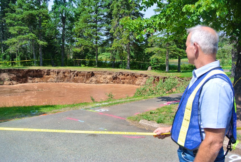
OXFORD, N.S. — Oxford’s Lions Park, closed last August by a massive sinkhole, is unlikely to ever reopen.
A geotechnical report into last August’s sinkhole has indicated the land in the park is unstable and that other sinkholes could develop on the property. For that reason, the Oxford Lions Club has decided to look for another location in the community for its park.
“We’ve elected to keep the parkland closed indefinitely because of the risk of further subsidence or additional sinkholes opening,” Robert Moores, president of the Oxford Lions Club, said. “Right now we’re looking at options for the park and the building, perhaps moving or selling the building. We’re looking for a new place to house the park.”
It was at this time last year that a massive sinkhole developed in the park forcing the club to shut down its community centre and restrict access to the park. The sinkhole continued to develop through September and is approximately 32.6 metres by 38.7 metres in diameter.
The sinkhole is located in what’s known as the Windsor Group that occurs throughout the province in places like Windsor, Falmouth, Cape Breton and elsewhere. Gypsum is part of that geological feature and it’s a mineral prone to sinkhole development because it’s soft rock that can dissolve through either groundwater or surface runoff.
Oxford CAO Rachel Jones said the report warns of instability in the property.
“There is some instability in other areas of the property, primarily toward the back of the property, but it can’t be specific to where because of inaccessibility with the equipment,” Jones said. “There are a couple of areas around the changerooms and toward Main Street that there’s potential for additional risk there.”
Jones said the report said the sinkhole that developed last summer was called a “cover collapse” and there’s no advance warning or notification of a sinkhole developing.
“There’s a void or area under the present sinkhole that potentially could open up,” Jones said. “I understand there’s a bit of a plug at the bottom and if you add extra weight to the property it could open up that plug, which could be catastrophic for the property. We just don’t know.”
In April, Cumberland-Colchester MP Bill Casey announced $68,500 in funding for the federal share of the geophysical testing through ACOA’s Innovative Communities Fund and GHD Ltd. was hired to conduct the testing including completing an image of the subsurface without digging, including electrical resistivity and seismic testing looking for rocks and potential voids.
The preliminary report was delivered to the town in late July with the final report being released within the last week.
Jones said there are several options the town can consider.
“There are geotechnical things we can do to try to prevent any cave-ins but that’s really expensive. Monitoring is an option that should be considered, especially anything that could be encroaching on public infrastructure,” she said. “It could be flying drones regularly, LIDAR mapping, visual inspection and survey. We haven’t reached that point yet and we need to talk to some people about the best course of action and what it might cost.”
Jones said the town has to walk a fine line because the park is not its property, but it will be watching the property close to the road and will be working with Energy and Mines, which she said has in its plan to monitor for geohazards.
“We will be talking to them to see what it means and see if we can collaborate or partner on that,” she said.